Introducing Neelum Valley
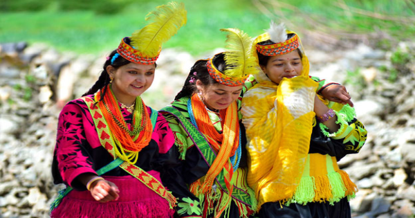
Neelum is a beautiful valley containing about 370 small and large villages and near about two hundred thousand population. It starts from Chelhana and goes till Taobut 250 km long. It is named Neelum due to its river, curving like the snake with transparent sky colored water. Like any other population of the subcontinent it has the most heterogeneous population with variety of rituals, customs and traditions. The whole valley is full of beautiful and fascinating sceneries.
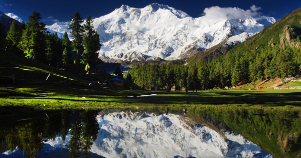
Neelum Valley is dipped in beauty Neelum valley about 252 km long and 3620 sq km curvature shaped with majestic pine, fir and deodar trees, lies north-south of Muzaffarabad. This ninety-mile long kingdom of vegetation is ripped apart by the indigo blue Neelum river which flows serpentinely down hills to merge itself into the river Jhelum at Domail. Domail, the confluence of two mighty rivers, presents highly fascinating scene of youthful embrace. This heart-warning spectacle is most soothing to the eye. Neelum Valley is situated to the North & North East of Muzaffarabad and running parallel to the Kaghan Valley.
It is separated from it by snow covered peaks, some over 4000 meters above sea level. Excellent scenic beauty, panoramic view, towering hills on both sides of the noisy Neelum river, lush green forests, enchanting streams, high altitude lakes and attractive surroundings make the valley a dream come true. The swaying lush green forests, snow capped mountains, streams singing songs of joy, and fast flowing river Neelum, all go together to make it naturalist’s wonderland. The area is also ideal for mountain tourism. A part of Nanga Parbat gigantic falls in this area which is dominated by "Sarwaali Peak" (6326 meters) the highest mountain in Azad Kashmir. Moreover like Kaghan Valley it is famous for fishing and angling activities in Neelum river and Jagran Nullah which are stocked with trout fish. Its sole tourist attraction is a seventeen (17) century fort built by the town’s founder, a chief of the Chak tribe named Muzaffar Khan, to ward off the Mughal armies of Emperor Akbar. Neelum valley is an attractive place for tourists due to its famous lush greenery, springs, streams, lakes and hilly and sloppy mountains.
There are two approaches to the valley. One from the Kaghan Valley which is linked with it at two points, the Noori Top (Pass) and the Ratti Gali and many minor Passes. From Dawarrian it takes two days for hiking or riding and night stay at Dharian at 12,000 feet. The second approach is from Muzaffarabad. It is a distance of 55 miles which is jeep able in fair weather. The Neelum meets the Jhelum river at Domali (meeting of the two) on the outskirts of Muzaffarabad city. From Paticka forest one reaches Nosari, 24 miles ahead of Muzaffarabad. Next come Chelhana (height 3,200 feet), Qazi Nag, Barian, Salkhala, Jura, Kundalshahi, Authmuqam on this road.
Some of its famous places like Shounter Pass, Chita Khata, Ratti Gali, Baboon, Noori Top, Sharda, Kel, Surgon and many more are mentioned by famous tourists like Mustansar Hussain Tararr, Ibn-e-Batota etc. Tararr even wrote a travelogue, Ratti Gali after visiting this place.
Traveling during May to October from the scorching heat of plains to the high land basin of Neelum Valley is indeed an escape from hell inferno to the cold breezes of paradise. The temperature remains in between 65°F to 90° F during the summer. The upper portion of the area normally receives first snow fall in the month of October and at some times even during September.
The valley, starting from Muzaffarabad, the capital of Azad Kashmir, is about 150 miles long. The first district of Neelum is Chelhana about 43 km from Muzaffarabad just after crossing the Nosari Bridge by the route of Neelum road. It lies on both sides of the river Neelum. The geographical features enhance the natural beauty of the Valley. Its elevation, a mere 2,000 feet at the start, gradually rises till it attains a respectable height of 8,000 feet. On both sides there are high mountains and peaks. Nearly all the forest wealth of Azad Kashmir is to be found in this part of the State.
Popular Attractions
The starting point of district Neelum about 43 km from Muzaffarabad just after crossing the Nosari bridge by the route of Neelum road. It is famous for its marble mines, from where marble is transported to Muzaffarabad and cities of Pakistan. Here is also a crossing point where people on both sides of LOC meet there relatives by crossing the bridge twice in a month. This meeting is possible after a long documentary process which is started with the consensus of both sides governments after the earth quack of 2005. On the opposite side of Chelhana is Tetwal under Indian occupation. Kerna the famous historical place is near Tetwal which is also told the capital city of ancient Kashmir by folks and even historians.
From here to Kundalshahi there are many small and large villages on the both sides of Neelum River, about 18 km forward is a link road Leswa bypass that leads to the top Chugali and many more beautiful mountains. Important stations in the way from Chelhana to Kundalshahi are Barian, Bandi, Leswa, Mirpura, Jura, Slampura and Chembher.
Jura Camp
About 60 kilometer from Muzaffarabad a small village consisting 3000 population, first main market after entering District Neelum, Jura is a village with scattered population on both side of river. It is the beginning point for Leswa bypass road and for mountain villages like Kutha Chugali and Chunj Top. For scenic point of view Nakka, Baandi and Leswa are place worth to visit.
Kundalshahi
Kundalshahi is 74 km from Muzaffarabad and about 5 kilometers from Authmuqam, another midway station, and a small commercial centre. In Authmuqam and Kundalshahi almost all basic necessities are available in the local market. Being a commercial centre it is congested and over crowded. Jagran stream joins the Neelum river here which has a glass light clean water and a suitable habitation for trout fish. A small hydro electric power is installed on this stream in Kundalshahi which provide electricity to Kundalshahi and Authmuqam. From Kundalshahi a link road leads to Kutton, Jagran and other tops. At the end of Jagran hilly tops reflect amazing scenes and are worth to see. Kiyan Shareef is an adjacent village that has reputation as land of holy saints. And annually Urs ceremonies are celebrated which attracted a large number of devotees from Kashmir and from Pakistan. A Sherries is there for devotees.
Kutton and Jagran
The picturesque Kutton and Jagran are best to visit during April to October. Nestled in the lower part of Neelum valley, the picturesque "Jagran" is its inseparable part. Jagran Nullah (stream) is indispensable and plays pivotal role in the formation of its landscape beauty and charm which reveals the richness of the area. The area is 16 kilometers from Kundalshahi and is accessible by road. For the convenience of tourists, AJK tourism Department has constructed a rest house here. A mega hydro electric project is installed here that produce electricity to the state. A long a beautiful series of Himalayas mountain starts from here to Kaghan, Skardu and Chillas.
In Jagran places like Kutton, Thunian, Ghansee and Pattlian Sar are worth-seeing and inviting everyone to visit and enjoy. Jagran is ideal for mountaineers and takers too. Here the mountains are ranging from 4000 feet to 1400 feet above sea level. The ever green forests are stretched in the far flung lush green plateaus with abundance of wildlife.
On the side lane of the impressive tourists resort the ever flowing greenish and surf gushing waters of Jagran Nullah add to its peculiar character. Jagran Nullah, rushing downwards all along the tall grooves of trees is almost small river. Surrounded by scintillating beauty under the shades of the majestic snow-clad mountains the river is freezing cold. The snowmelt of these sky heights named "Jagran Nullah" is also know for rout fishing attracting angles all over the seasons.
Salkhala
Not more than 3 kilometers from Kundalshahi across the river Neelum one can enjoy the lovely place Salkhala. A Trout hatchery has been established by the Azad Kashmir Fisheries Department. A reasonable accommodation facility is available here.
Kutha Peran and Meengal
About 8 km forward from Kundalshahi just before entering Authmuqam a jeep able road lead to this series of small villages. Meengal and Kalkore about 1580 meter from sea level are the last villages of this series. A stream which is main source of water for cultivation for Authmuqam and for this village is flowing mid of the whole these village and falls in river Neelum at the place of Shahkot. Area is distinguishable for its rich scenic beauty, frequent waterfalls, typical life style, special cultivations and production of pottery.
Authmuqam
Authmuqam is situation at 10 kilometers from Kundalshahi is the Sub Divisional Headquarter of the area. It contains all the civic services to a certain extent like hospital, post office, bank, a telephone exchange and a few small bazaars. If you need anything then you must buy it from here because this is the last stop where you can find reasonable commodities in quantity as well as in quality. Apart from the fact that this valley town is very unique in its beauty with respect to the other places we had yet visited, it is also significant as it marks the beginning of control line with Indian Held Kashmir in Neelum. It is another important station and well populated city in the valley. Having an altitude of about 1371 meters above sea level is located at a distance of 80 Kms from Muzaffarabad is connected by Neelum road. It is named Authmuqam because it is 8th station from Muzaffarabad to upper valley. Most people are government employees, rest are in different fields. A large number of government and private institution is working here including one high standard private and two government colleges. From here upwards emerges typical Kashmiri living pattern with houses built of wooden logs, most of them double storied. Authmuqam in its geographical structure is a cup like valley with green hills on the four sides. Hiking tracks for surrounding mountains are traced by peoples and tourists.
Neelum (Karen)
At a distance of about 9 Kms from Authmuqam, Neelum opposite to the Karen village (Indian occupied Kashmir) having an altitude of 1524 meters above sea level is very popular among tourists. A tourist rest souse run by AJK tourism department is situated on the bank of River. Due to its importance from tourism point of view, AJK tourism department is giving special attention to it. From Karen a link road leads to Neelum which is one of the most beautiful villages of Neelum Valley. A zoo and park is under construction, Neelum is also accessible via Karen By-pass starts from Authmuqam.
Nagdar
It is situated, about 25km from Authmuqam the district headquarter at attitude of about 1645 meters. Nagdar is famous for its scattered population on hilly grooves. It is famous for fine quality bean crop which is cultivated at a large land and supplies to the whole valley and out of the valley. Like Kutha Peran this whole series of village is situated on the both side of Nullah Nagdar and a lot of water mills are constructed on it for grinding Maize which is its major crop. Another thing is that most of people are attached with teaching profession.
Dawarrian
Dawarrian at a distance of 13 Km from Neelum at an altitude of 1615 meters is surrounded by mountains full of conifer trees. Over here a mule-track up to Ratti Gali Pass (4140 meters), about 30 Kms toward west congest the Neelum and Kaghan Valleys. The pride of valley is the large fresh water lake nestled in the mountains. Vast plain is surrounded by the small yet beautiful lake and gushing water.
Dodnial
This place is situated about 32 kilometers forward from Authmuqam at an altitude of about 1560 meters. It is also a beautiful place of the both side of Neelum river. Potatoes are the major production of this area. Most people are dependent on their own cultivated sources and a large number is also associated with government and private jobs.
Sharda
The most picturesque place in Neelum Valley is Sharda it is located at a distance of 136 kilometers from Muzaffarabad and 30 Km from Dawarrian. Sharda is one of the most beautiful places with its lush green planes, smooth flowing river which frozes in sever cold season and serves as passage for people of both sides of the river. This place from the point of view of tourists is so attractive and captivating that they get their money’s worth when they spend a few days here in their sojourn amidst nature. In Sharda one also finds ruins of an old place of learning. The presence of these ruins lends Sharda is a historical background providing special attraction for the people interested in archaeology and history. The most important site of Sharda is its haunted university remains which are said remains of a great university of the Asia in Buddhist era. This university was the center of knowledge for the people of China, East and Central Asia. It remained the attractive place for knowledge seeker for a long time that came by the route of Jammu instead of Muzaffarabad. But due to some unknown major accident this university lost its light and existence and vanished completely from the land and even from the history, alongside the university the remains of a fort.
Kel
This place is situated 90 km from Authmuqam and 19 kilometers journey from Sharda, which is at the height of 2097 meters above sea level. This is another picturesque place in the Neelum Valley. The Shounter Nullah joins river Neelum at this place and leads to Gilgit Agency over the Shounter (4420 meter above sea level). Buses run daily on this route in good weather. Kel is also a base camp of mountaineering activities up to Sarawaali Peak 6326 meters above sea level and "Sarawaali Glacier" which are said to be the highest peak and biggest glacier of Azad Kashmir. Rest Houses facilities are available. Form Kel a long track goes towards Nanga Parbat over the 4420 meters Shounter Gali.
Halmet
This village is situated 38 kilometers from Kel. From Kel to forward jeep able road is available for Halmet, the valley above the Kel is also called Grace valley with its harsh and frozen weather in winter season, people have a typical life style. A tourist rest house had been constructed a Halmet to provide accommodation facilities to the visitors. Halmet has fascinating beautiful scenes yet unexplored. Janwai, Phulawai, Sardari and Halmet are the most beautiful places around here.
Taobut
The last station of Neelum Valley is Taobut and end point of Pak beauty in Kashmir. It has a sever season and heavy snow in winter, and winter season continue about 6 months starting from October to April end. Often there are no signs of path due to land sliding and flooded water streams. In summer it is a worth place for tourist to visit.
Trekking in Neelum Valley
Neelum Valley provides a variety of treks at varying altitudes durations, ranging from a day to a week via from Dawarrian or Sharda to Ratti Gali with duration of 3 days, reaching a maximum altitude of 4140 meters and the trek can be extended to the Kaghan Valley by crossing the Ratti Gali Pass. Near the pass one can see an ideal natural lake "Ratti Gali" at an altitude of 3832 meters and other five little lakes around them. A challenging trek of a week’s duration is from Kel to Astor via Shounter Gali, reaching a maximum altitude of 4260 meters.
The area is well connected by road, more than half of it from Muzaffarabad is black topped, while remaining is all weather (un-metalled), which is being metalled. A regular bus service up to Kel is available. However you can drive in your own car up to Dawarrian from there onwards you have to switch over to Jeeps for your drive.
Total Area: 3621 Sq. Km. - Total Population: 197000 - Administrative Setup (2 Tehsils) - Authmuqam & Sharda
Road Links
Via RawalpindiMuzaffarabad
Rawalpindi-Muzaffarabad (137), Muzaffarabad-Authmuqam (85Kms), Muzaffarabad-Karen (93 Kms), Muzaffarabad-Sharda (136 Kms), Muzaffarabad-Kel (159 Kms), Kel-Taobut (250Kms)
Via Kaghan- Julkhad
Muzaffarabad -Kaghan (104 Kms), Naraan (128 Kms), Julkhad (173 Kms), Noori Nar Top (192 Kms), Sharda (228 Kms), Kel (251 Kms), Kel-Taobut (340Kms)
Tourism in Neelum Valley
Mountain based adventure Tourism
Common routes for hiking/ mountaineering are
Jagran Route: Kundalshahi - Jagran - Shakharan – Baboon – Ratti Gali.
Karen Route: Karen - Neelum – Nagdar - Karka - Khoree.
Dawarrian Route: Lawat – Dawarrian - Upper Dawarrian - Ratti Gali.
Goother Route: Authmuqam - Rawota - Goother - Shaheen.
Kaghan Route: Sharda – Ghumote- Kaghan - Chillas.
Astore Route: Sharda – Surgon – Shounter.
Tao Butt Kamri Pass- Astore Route.
Arng Kel, Sharda and Narda Village.
Scenic Beauty (based on ECO Tourism)
Mirpura, Kutton, Jagran Valley, Authmuqam, Lower & Upper Neelum Area, Dawarrian, Baboon, Ratti Gali, Noori Nar, Surgun, Sharda, Kel, Arng Kel, Halmet, Taobut, Domail Bela and Shounter Valley Area
Cultural Heritage of Neelum Valley
Halmet - Tao Butt Area for unique architectural style of buildings
Shounter Valley for its unique dresses/ costumes
Neelum Valley for its unique culture/ traditions
Historical / Archaeological Assets
Ruins of Old Buddha University in Sharda
Sharda Fort
Kishan Ghaati near Sharda
Districts Neelum
Some of the tourist places of Neelum Valley are situated in the range of Line of Control, therefore sometimes it become difficult to visit these areas. So before visiting the valley, the visitors are required to get information.
Syed Khalid Saeed Bukhari
Top Contributors


Sign in
to continue to ilmkidunya.com
Related Articles
Summer Vacations are here: Explore these beautiful places in Pakistan during your holidays
- Team Ilmkidunya
- 13/Jun/2023


.jpg)

Most Popular Articles


 Punjab Education Ministry Announces The Matric And Inter Final Result Schedules For All Boards Of Education
- Date: 23/Sep/2021
- Category: Education